Trek to Phoksundo Lake and the Bon heartland of Dho Tarap, crossing two passes above 5,000m through Nepal's rain-shadow desert.


Numa La at 5,190m and Baga La at 5,070m crossed on consecutive days
Nepal's deepest lake at 3,611m, turquoise water, 167m waterfall
The largest Bon religion village in Nepal at 4,090m
RAP, national park, TIMS and municipality permit all included
Lower Dolpo is a 19-day semi-camping trek through the Dolpa district of western Nepal, a restricted area sitting behind the Dhaulagiri massif in the rain shadow of the Himalayas. Annual rainfall in the upper Tarap Valley drops below 200mm. The landscape shifts from pine-forested river gorges near Dunai to high-altitude desert above Laini in a single day’s walk. You fly from Kathmandu to Nepalgunj and on to Juphal at 2,320m, then walk through the Tarap Valley to Dho Tarap at 4,090m before crossing Numa La at 5,190m and Baga La at 5,070m on consecutive days and descending to Phoksundo Lake. The route French director Eric Valli followed for nine months while filming “Himalaya” in 1999, the first Nepalese film nominated for an Academy Award, runs through the same valleys, villages and lake on this itinerary.
This is a demanding trek with two consecutive high pass crossings and a total of 12 to 14 days without reliable mobile signal or medical facilities above Dunai. Previous high-altitude experience above 4,500m is required. The terrain is remote and self-sufficient by design. Where teahouses exist in Dunai, Tarakot, Ringmo and Chhepka the group stays in local lodges. Above teahouse range MountainKick’s cook and kitchen crew set up a full tented camp with individual sleeping tents, mess tent and hot meals. You carry only a daypack on the trail. The reward is access to a landscape and culture that fewer than a few hundred trekkers reach each year. Dho Tarap is one of the last places in Nepal where the Bon religion is still the primary practice of an entire village community, with prayer wheels spinning anti-clockwise and monasteries oriented differently from Buddhist gompas.
MountainKick handles all four permits before departure including the Restricted Area Permit, Shey Phoksundo National Park entry, TIMS card and Dolpa Municipality permit. A licensed guide is mandatory by law and a minimum group of two trekkers is required to obtain the RAP. For trekkers who want to go deeper into Dolpo, the Lower Dolpo Trek connects naturally with the Upper Dolpo Trek for a 30-plus day combined expedition. Read our Altitude Sickness guide and Travel Insurance guide before booking.
Your guide meets you at Tribhuvan Airport and transfers you to your hotel in Thamel. The evening briefing covers the full 19-day route, permit logistics, gear check and the Nepalgunj flight schedule. Download offline maps before you sleep as reliable internet ends at Dunai. This is also the last chance to withdraw cash for the full trek.

A full day for permit processing, gear check and trek briefing with your guide. MountainKick handles the RAP, Shey Phoksundo National Park permit, TIMS card and Dolpa Municipality permit paperwork. Use the afternoon to purchase any last-minute gear, withdraw cash and confirm domestic flight tickets. This is the only day with reliable internet before Dunai so back up devices, sort communications and download offline maps.

A one-hour flight from Kathmandu drops you into the western Terai plains. Nepalgunj sits at 150m, noticeably hotter and more humid than Kathmandu, and serves as the transit hub for all Dolpo flights. The afternoon is free. Charge every device fully tonight as reliable electricity ends here. An early night is essential as the Juphal flight departs before sunrise tomorrow.

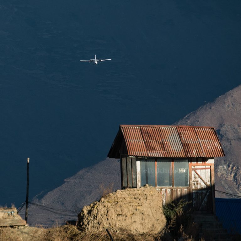
The 35-minute mountain flight to Juphal crosses the Chure Hills and approaches a short gravel airstrip flanked by steep ridges. From Juphal the trail descends through terraced maize and barley fields above the Thuli Bheri River to Dunai, the administrative headquarters of Dolpa district. Dunai has a small hospital, a police post and a permit checkpoint. It is the largest and best-equipped settlement on the entire route.

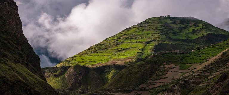
The trail follows the southern bank of the Bheri River upstream through deep gorges crossing several suspension bridges strung above the fast-moving river. Blue pine forest lines the gorge walls and views of Kang Tokal at 6,294m appear to the north as elevation is gained. Tarakot sits on a hilltop above the river with terraced fields of buckwheat and barley visible from the trail below. It is the last reliable teahouse before the route enters the Tarap Valley.
Leaving Tarakot the trail enters the Tarap Chu river valley, the main drainage of the upper Tarap. The landscape transitions from pine-forested gorges to a wider, drier valley as altitude increases. The route passes through Khani Gaon and Chhyujar, where the 11th-century Sandul Gompa sits just off the trail and rewards a short detour. Shey Phoksundo National Park begins at Laini where permits are checked. Mani walls and chortens become more frequent from here.
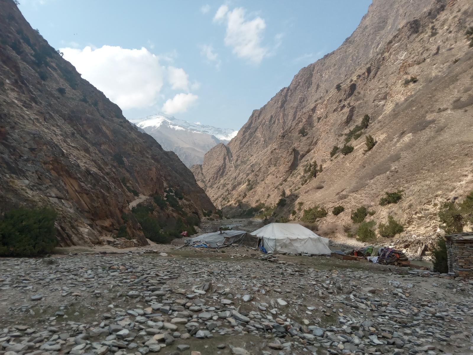
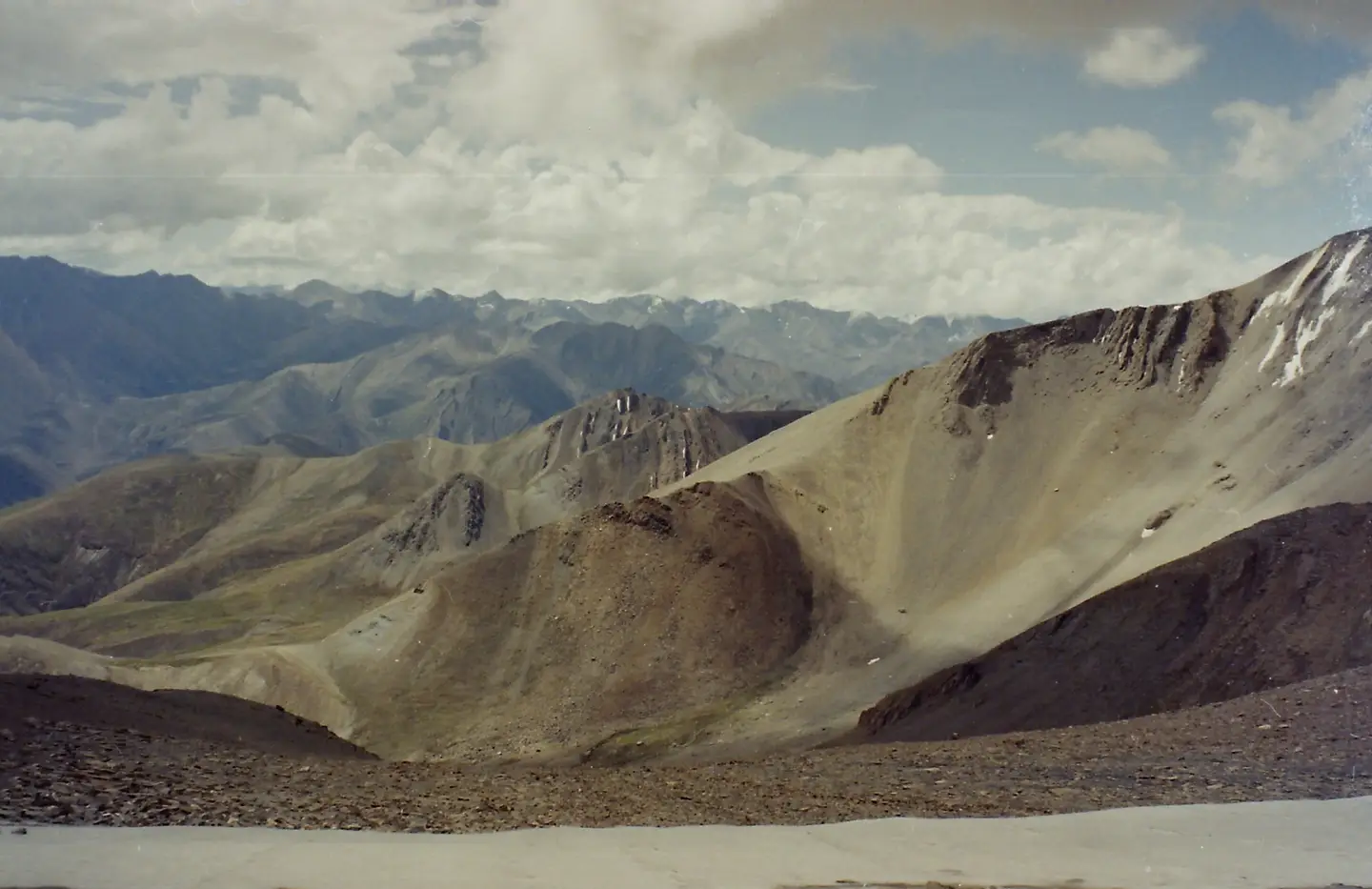
The valley walls close in and the trail climbs through increasingly arid terrain carved directly into cliff faces in several sections, passing naturally formed rock tunnels and overhangs. Vegetation is sparse from here: juniper, scrub and high-altitude grasses replace the pine forest of the lower valley. Blue sheep are commonly sighted on the surrounding ridges from this point. Nawarpani marks the gateway to the high Tarap plateau and the last water source before the final climb to Dho Tarap.
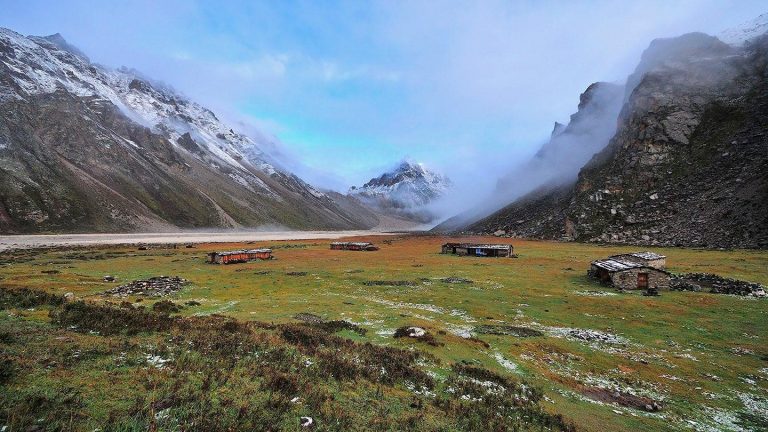
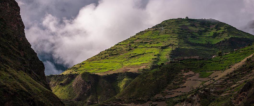
The plateau opens dramatically as the trail approaches Dho Tarap, shifting from tight canyon walls to broad open sky in less than two hours. Dho Tarap has 34 stone houses divided into three clusters, two Bon monasteries including the Sipchok Dedhen Phuntsokling Bon Monastery, and a small health post. The Ribo Bhumpa Gompa, a Nyingmapa Buddhist monastery built in the sacred vase style, sits above the village on the ridge. This is the highest permanently inhabited village in Nepal and the cultural heartland of the Bon religion.

A full rest day before the two consecutive high pass crossings. Spend the morning visiting the Bon monasteries and watch for prayer wheels spinning anti-clockwise and circumambulation paths oriented counter to Buddhist practice. A short afternoon walk on the plateau above the village assists acclimatisation. If timing aligns with a yak caravan departure or arrival from Tibet it is one of the most vivid travel experiences available anywhere in Nepal. Do not skip this day.

Leaving Dho Tarap the trail heads north through the arid upper valley passing Tokyu Gaun, a small settlement with a Buddhist monastery worth a short stop. The landscape is fully above the tree line as the route climbs through yak pastures and rocky moraines toward the base of Numa La. Views of the Dhaulagiri massif build as altitude is gained. Arrive at base camp early, eat well and sleep early. Tomorrow is the hardest day on the trek.
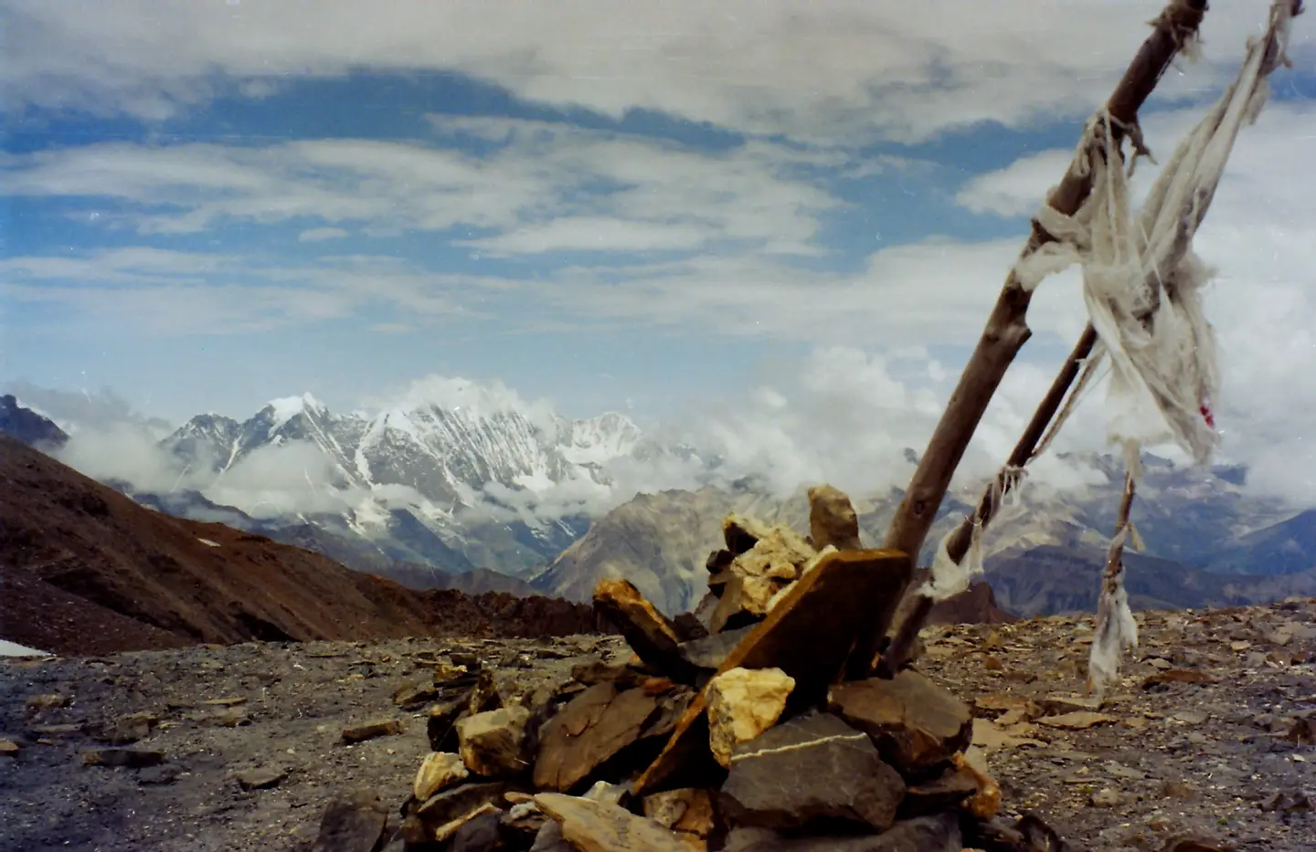
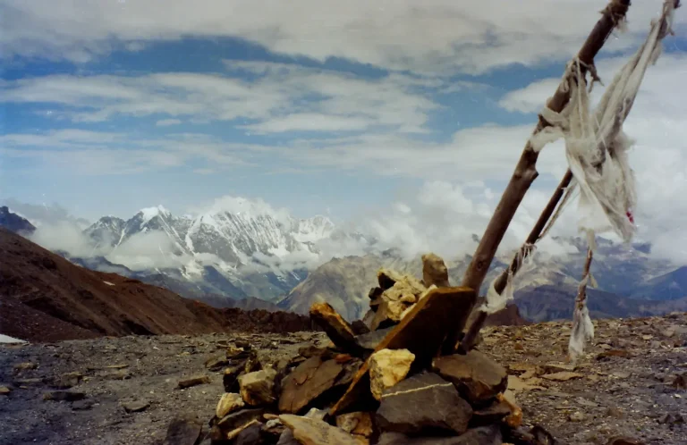
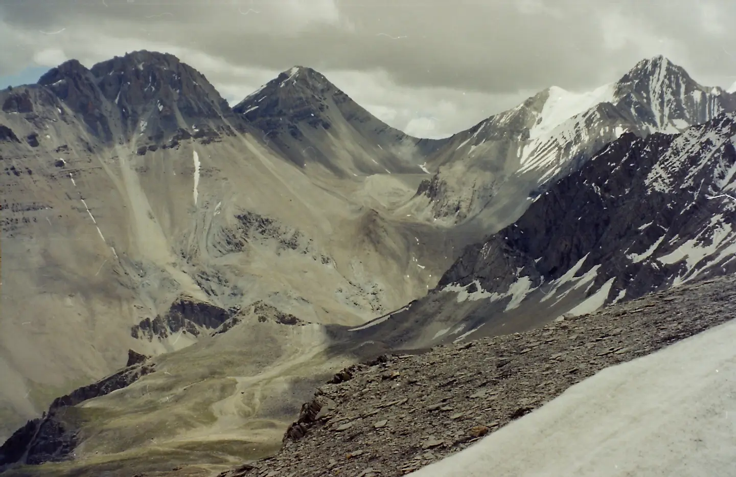
Departure at 4am by headtorch. The climb to Numa La at 5,190m gains 750m from base camp over 3 to 4 hours on steep rocky terrain. Prayer flags and chortens mark the pass. Views extend across the Kanjiroba Himal, the Dhaulagiri range and the vast arid plateau of inner Dolpo. The descent to Pelung Tang is long on tired legs. Pelung Tang is an isolated grassy plateau at 4,445m with no teahouse. From here the first glimpse of Phoksundo Lake is visible far below on clear days.
A second consecutive high pass crossing with yesterday’s exertion still felt at altitude. The ascent to Baga La at 5,070m is shorter than Numa La but demands the same careful pacing. Views from the top include Norbung Kang at 6,085m, Kanjiroba Himal at 6,612m and on a clear day the turquoise surface of Phoksundo Lake visible far below. The descent to Dajok Tang follows a steep gorge before levelling into green juniper forest and meadow. Phoksundo is now one day away.
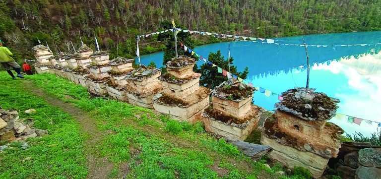
A shorter, easier day after two consecutive high passes. The trail descends through pine and birch forest with the Maduwa Khola visible far below before the path climbs back up over beautifully carved high rocks toward Ringmo. The lake comes into full view on the final approach. Ringmo is a small Bon community of roughly 30 households with flat-roofed stone houses, a working monastery and terraced barley fields above the turquoise water. After five days of high camp, a teahouse bed feels like a luxury.

A full day at Nepal’s deepest lake. Phoksundo sits at 3,611m, covers nearly 500 hectares and reaches 145m depth. Its turquoise color comes from dissolved minerals and the complete absence of aquatic life. A trail circuits part of the shoreline with views of the 167m waterfall dropping from the lake’s northern outlet. Sandul Gompa, an 11th-century monastery on the opposite shore, is reachable by a 2 to 3 hour walk from Ringmo. Eric Valli filmed key scenes of “Himalaya” on these shores in 1999 and the landscape has changed very little since.

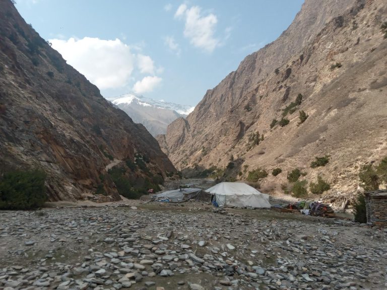
Leaving Phoksundo the trail descends steeply through pine and birch forest along the Phoksundo Khola gorge passing beneath enormous overhanging cliffs. The descent from 3,657m to 2,530m in a single day is significant and the knees feel it on the rocky trail. The route passes settlements where traditional mineral medicines are still traded and exits Shey Phoksundo National Park at the checkpoint near Chhepka. Basic teahouse facilities and a lower altitude make the night here noticeably warmer than anything since Tarakot.

The final trekking day follows the Phoksundo Khola downstream through birch forest crossing the Dhim Khola suspension bridge before the trail climbs through Shyanta and Kageni villages. The national park checkpoint is crossed for the last time here. A gradual ascent through open meadow leads to Juphal where the crew is thanked and tipped at the airstrip. The Juphal flight departs early morning so an early night is essential. Fifteen days of remote trail ends here.

Morning flight from Juphal to Nepalgunj, 35 minutes. Mountain weather can delay departure so early morning slots have the best chance. Nepalgunj is warm, flat and a complete contrast to the landscape of the past two weeks. Use the afternoon to rest, shower properly, do laundry and eat fresh food unavailable on the trek. The cook and kitchen crew are thanked here before parting ways. MountainKick arranges a farewell dinner this evening to mark the end of the route.
A one-hour flight returns you to Kathmandu where a vehicle transfers you back to your hotel in Thamel. The afternoon is free for last-minute shopping, a final visit to Boudhanath or Pashupatinath, or simply recovering with good food and a hot shower. Use the evening to sort permits, tips and any remaining logistics before tomorrow’s departure.

Your guide transfers you to Tribhuvan International Airport for your onward flight. If your flight departs late the morning is free for a final walk through Thamel. Build at least one buffer day before long-haul international connections given the Juphal flight variability two days prior. Nineteen days, two passes above 5,000m, Nepal’s deepest lake and the Bon heartland of Dho Tarap. Safe travels.

2 nights in Kathmandu: Three-star hotel in Thamel with twin sharing rooms, hot shower, WiFi and daily breakfast included. Same hotel on arrival and return.
2 nights in Nepalgunj: Standard hotel with private bathroom, air conditioning and hot water. Nepalgunj has reliable electricity and internet — the last chance to charge devices fully before the trek.
Teahouse nights (Dunai, Tarakot, Ringmo, Chhepka): Basic twin sharing rooms with shared bathrooms and blankets provided. Dunai is the most comfortable with a small hospital and a few decent lodges. Ringmo on the lake shore is the highlight teahouse stay of the trip. Chhepka is functional and basic.
Tented camp nights (Laini, Nawarpani, Dho Tarap, Numa La Base Camp, Pelung Tang, Dajok Tang): MountainKick sets up individual sleeping tents, a mess tent for group meals and a separate kitchen tent. Foam sleeping mats provided. A sleeping bag rated to -15C is mandatory for the high camp nights above 4,000m. Single tents are standard for all trekkers.
All meals included from Day 4 to Day 17. Dal bhat, noodle soups, fried rice and eggs at teahouses. The cook prepares three hot meals daily at camp. Fresh vegetables disappear above Tarakot. Meat avoided above Dunai. In Kathmandu and Nepalgunj only breakfast is included. Farewell dinner on Day 18 is included.
| Meals in Kathmandu and Nepalgunj | $10 to $20 per meal |
| Alcoholic drinks on trek | $3 to $8 per drink where available |
| Soft drinks and bottled water | $1 to $3 per bottle |
| Personal snacks and energy bars | $50 to $100 total recommended |
“I’m already planning for the trip AGAIN and you would know which company I’d choose AGAIN…”
Finally, I had the opportunity to meander across the splendor of the Himalayas. My first concern after researching everything there was to know about Nepal was my safety and my child’s welfare. But upon our arrival at the airport, I found out that Kathmandu is one of the meanest places…
“MountainKick is haven for trekkers and one cannot afford to miss it if you are interested in trekking in Nepal.”
To whoever reading this and wondering about the legitimacy of this company, they are for real. The team is genuinely dedicated to making your trekking memorable and rewarding. Such is the professionalism of the company that they went steps further to assist us that included the tracking down of the…
“We liked the concern of this company for its staffs and the environmental awareness and it has.”
There was always a response from Jagat as we had so many things to ask. We had insisted on having a Nepali guide instead of a westerner because we had to make sure the money we spend actually goes to Nepali people. We chose this company because we had heard…
“We had the trip of our lifetime”
We had the trip of our lifetime thanks to the warm hospitality bestowed upon us and the beauty of such amazing country. From well-organized trips, exotic locations, cultural sightseeing to the thrill of safari, “soft” trekking to Poon Hill, everything was memorable. Our trekking guide was Shiva, apparently named after…
Lower Dolpo centers on the Tarap Valley, Dho Tarap village and Phoksundo Lake with a maximum altitude of 5,190m at Numa La Pass. Upper Dolpo goes deeper into the restricted zone to Shey Gompa and Crystal Mountain, costs significantly more due to the Upper Dolpo permit at $500 per person for the first 10 days versus $20 per week for Lower Dolpo, and requires more time at 24 days minimum. Lower Dolpo is the better starting point for anyone new to Dolpo. The two can be combined into a single 30-plus day expedition. Read about the Upper Dolpo Trek for comparison.
Four permits are required: the Restricted Area Permit at $20 per person per week, the Shey Phoksundo National Park entry permit at $30 per person, a TIMS card and the Dolpa Municipality permit. All four are arranged and paid for by MountainKick as part of your package. You do not need to visit any government office yourself. Bring four passport-sized photos and your passport details when you contact us to begin the process. For a full breakdown of Nepal permit costs read our Nepal Trekking Permits 2026 guide.
Bon is the pre-Buddhist spiritual tradition of Tibet and the Himalayas, predating the arrival of Buddhism by several centuries. In practice the differences are visible on the trail: Bon practitioners walk anti-clockwise around stupas, chortens and mani walls while Buddhists walk clockwise. Bon monasteries are oriented differently and the iconography uses distinct symbols. Dho Tarap at 4,090m is one of the last places in Nepal where Bon is still the primary religion practiced by an entire village community. Your guide will explain the specific practices visible at each monastery on the acclimatisation day.
Semi-camping means the trek uses teahouses where they exist — Dunai, Tarakot, Ringmo and Chhepka — and tented camps where they do not. MountainKick provides a full camping setup for the high sections: individual sleeping tents, a mess tent for group meals, a kitchen tent and foam sleeping mats. The cook prepares three hot meals per day at camp. You carry only a daypack on the trail. A sleeping bag rated to -15C is required for the high camp nights above 4,000m.
We rate this trek Hard. Previous high-altitude trekking experience above 4,500m is strongly recommended. The two consecutive pass crossings on Days 11 and 12 — Numa La at 5,190m and Baga La at 5,070m — are the hardest days and require a 4am start with 8 to 9 hours of walking. Above Dunai there is no road access, no mobile signal and no medical facility. Lower Dolpo is more demanding and more remote than Manaslu or Everest Base Camp. If you have not previously trekked above 4,500m start with the Everest Base Camp Trek or Manaslu Circuit Trek first.
Juphal is a high-altitude gravel airstrip in a narrow valley and flights are frequently delayed or cancelled due to cloud cover, wind or visibility. Morning slots have the best chance of departing on time. If the outbound Juphal flight is cancelled the group waits in Nepalgunj until conditions improve — this is why Day 3 in Nepalgunj is built into the itinerary as a buffer. On the return a night in Nepalgunj on Day 17 serves the same purpose before the Kathmandu flight. A buffer day in Kathmandu before your international departure is strongly recommended. Read our Lukla Flight Delays guide for context on mountain flight variability in Nepal.
Your policy must cover helicopter evacuation above 5,200m to a minimum of $100,000. Standard travel policies often exclude high-altitude rescue so check the fine print carefully before purchasing. Helicopter evacuation from a remote location in Dolpo can cost $5,000 to $15,000 without insurance. We ask to see proof of insurance before the trek begins. Read our Travel Insurance guide for what to look for in a policy covering Nepal restricted area trekking.
Partially. Dolpo sits in the rain shadow of the Dhaulagiri massif which blocks most monsoon moisture from the south. Annual rainfall in the upper Tarap Valley is below 200mm — drier than many European cities. July and August are possible but the lower trail sections below Laini receive more rain, leeches are present in forested areas and trails can be muddy. The passes are generally clear of snow in monsoon. Autumn from September to October remains the most reliable window. If your schedule only allows a summer trip Dolpo is one of the few Nepal regions where it is worth considering.
Yes, two extensions work well. The Upper Dolpo Trek extends the journey deeper into Dolpo via Shey Gompa and Crystal Mountain, adding 6 to 8 days for a combined 30-plus day expedition. Alternatively Nepalgunj is the gateway to Bardia National Park, one of Nepal’s best wildlife destinations with rhino, tiger, elephant and gharial crocodile in the Karnali floodplain. A 3 to 5 day Bardia safari can be added as a complete contrast to the high-altitude landscape of Dolpo. Contact Kumar when booking if interested.
The turquoise color comes from dissolved minerals and the complete absence of aquatic life — no fish, no algae, no insects on the water surface. The lake is 145m deep and covers nearly 500 hectares at 3,611m. The surrounding cliffs drop directly into the water on the northern shore. A 167m waterfall drops from the lake’s outlet gorge. Eric Valli spent nine months filming on these shores for “Himalaya” in 1999 and the landscape has changed very little since. Ringmo village on the southern shore has roughly 30 households and a working monastery. Most trekkers describe the lake as the visual highlight of the entire trip.
No upcoming fixed departures are scheduled at the moment. Contact us to arrange a private departure on dates that suit you.
| 30+ days before departure | Deposit forfeited, balance refunded in full |
| 15–29 days before departure | 50% of total trip cost charged |
| Under 15 days | No refund |
| MountainKick cancels trip | Full refund or reschedule |
We never force our customers to follow our set itinerary. You can customize your itinerary exactly the way you want. Please share with us your ideas.
"*" indicates required fields
| Item | Qty | Note |
|---|---|---|
| Down jacket | 1 | Minimum 600 fill power. Rentable in Kathmandu. |
| Waterproof hardshell jacket | 1 | Windproof and fully seam-sealed |
| Waterproof hardshell trousers | 1 | Over your fleece or base layer |
| Fleece jacket or midlayer | 1 | Polartec or equivalent |
| Thermal base layer top | 2 | Merino wool preferred |
| Thermal base layer bottom | 2 | Merino wool preferred |
| Trekking trousers | 2 | Quick-dry, not denim |
| Trekking shirts | 3 | Lightweight, quick-dry |
| Warm hat | 1 | Covers ears, fleece or wool |
| Sun hat or cap | 1 | Essential above treeline |
| Balaclava | 1 | For pre-dawn starts on Numa La and Baga La crossing days |
| Lightweight gloves | 1 pair | Liner gloves for most days |
| Expedition gloves | 1 pair | Waterproof, insulated for passes |
| Neck gaiter or buff | 1 | Dust and wind protection |
| Trekking socks | 5 pairs | Merino wool, vary thickness |
| Camp sandals or lightweight shoes | 1 pair | For tent and camp use |
| Item | Qty | Note |
|---|---|---|
| Trekking boots | 1 pair | Waterproof, ankle support, broken in before departure |
| Trekking poles | 1 pair | Essential for pass descents. Available in Thamel. |
| Gaiters | 1 pair | For scree and snow on high passes |
| Item | Qty | Note |
|---|---|---|
| Sleeping bag | 1 | Rated to -15C minimum. Rentable from us. |
| Sleeping bag liner | 1 | Adds warmth and keeps bag clean |
| Item | Qty | Note |
|---|---|---|
| Daypack | 1 | 25 to 35 litres for daily carry |
| Duffel bag | 1 | Provided by MountainKick. Carried by porter. |
| Dry bags or pack liners | 2 | Waterproof your gear inside the duffel |
| Small padlock | 1 | For duffel bag zip |
| Item | Qty | Note |
|---|---|---|
| Personal first aid kit | 1 | Blister treatment, bandages, antiseptic |
| Altitude sickness medication | 1 course | Diamox if prescribed. Discuss with your doctor before departure. Common dose 125mg twice daily from Dho Tarap upward. |
| Water purification tablets or filter | 1 | Stream water needs purifying above Dunai. No safe water stations above Tarakot. |
| Sunscreen SPF 50 | 2 | UV is intense above 4,000m |
| Lip balm with SPF | 2 | Essential on passes |
| Sunglasses | 1 | Category 4 UV protection for pass crossings |
| Insect repellent | 1 | For lower valleys and Nepalgunj |
| Hand sanitiser | 2 | Soap is limited at remote camps |
| Toilet paper and lighter | sufficient | Pack out or burn |
| Personal medications | sufficient | Bring more than you think you need |
| Blister plasters | 10+ | Compeed or equivalent |
| Item | Qty | Note |
|---|---|---|
| Headlamp | 1 | Essential for pre-dawn pass starts |
| Spare batteries or power bank | 2 | No charging points beyond Dunai. Charge everything fully in Nepalgunj before the Juphal flight. |
| Camera | 1 | Optional but you will regret not having one |
| Universal travel adaptor | 1 | For Kathmandu and Nepalgunj hotels |
| Item | Qty | Note |
|---|---|---|
| Passport | 1 | Valid for at least 6 months beyond travel dates |
| Travel insurance documents | 1 | Physical copy plus digital backup |
| Emergency contact card | 1 | Leave one copy with someone at home |
| US dollars cash | sufficient | ATMs end at Nepalgunj. Dunai has a small bank but reliability is inconsistent. Budget $10 to $20 per day for drinks and personal expenses only as all meals are included. Carry NPR 15,000 to 25,000 minimum. |
| Passport photos | 4 | Required for permits |
| Item | Note |
|---|---|
| Expedition sleeping bag | Upgrade to -25C rated bag. Essential in winter. |
| Extra thermal layers | Two sets of base layers minimum |
| Insulated camp boots | Standard trekking boots are not enough below -15C at camp |
| Hand warmers | Chemical warmers for pass crossings |
| Item | Note |
|---|---|
| Waterproof pack cover | Your duffel and daypack need independent covers |
| Extra dry bags | Double bag everything electronic |
| Leech socks | Essential in lower forested sections during monsoon |
| Quick-dry towel | Extra one for monsoon conditions |
We connect you with trusted shops during your prep day briefing the evening before the Nepalgunj flight. Do not buy gear at the airport.
Kumar and the team have guided this route for over a decade. Ask anything — gear, fitness, altitude, private groups — before you commit.

Ride 550 km from Kathmandu to Muktinath through jungles, Chitwan wildlife, Annapurna views, and the Kali Gandaki gorge on a 13-day adventure.

Remote Trek, Adventure, Essentials, Travel
Two base camps, four passes, 21 days. The honest guide to the Kanchenjunga Circuit: difficulty, permits, best time, costs, and whether you're ready for it.

Annapurna Region, Everest Region, Adventure, Essentials, Travel
No five-star hotels. No heated rooms. Here is what luxury trekking in Nepal actually delivers and why the private guide matters more than the lodge.
"*" indicates required fields